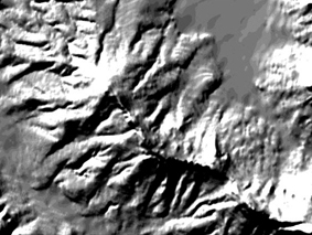
This innovation addresses the need for a high-resolution digital elevation model (DEM) of the entire terrain of South Africa. Unlike other commercially available DEMs, SUDEM provides an accurate, high resolution DEM of the entire terrain of South Africa. Data verification and error correction tools overcome the problems experienced with input data such as attribute errors in digitized contours and spot heights, spatial errors such as gaps and mismatching contours at the edges of map sheets, and certain voids in the SRTM DEM, resulting in a continuous, seamless DEM with minimum “edge effects.”
SUDEM combines various sources of elevation data to produce a single accurate, high-resolution DEM covering the entire terrain of South Africa.
Preference is given to data of large scale (i.e. 1:10000) contours and spot heights, while smaller scale (i.e. 1:50000) data are only used in areas where large scale data are unavailable.
By using a combination of algorithms, an intermediate DEM is produced by interpolating a high-resolution DEM from contours and spot heights of the various data sources. The intermediate DEM detects and corrects even the slightest of errors in the data, such as errors in the digitized contours and spot heights, spatial errors such as gaps and mismatching contours at the edges of map sheets, by way of an automated method. The elevation data from the different sources are fused in such a way that “edge effects” are minimized.
An enhanced resolution DEM is then provided by fusing the intermediate DEM with the original DEM, the intermediate DEM having a resolution higher than the resolution of the original DEM and the fusion being carried out in a manner that the contour information of the intermediate DEM only dominates in areas where the contour density of the original DEM is significantly lower than that of the intermediate DEM.
Article:Developing a very high resolution DEM of South Africa
Article:Data availability and requirements for flood hazard mapping
SUDEM provides a DEM having the following unique characteristics:
covers the entire terrain of South Africa;
higher accuracy and resolution than prior commercially available DEMs;
a continuous, seamless DEM with minimum “edge effects.”
A PCT application (PCT/IB2013/05117) has been filed and it has already been licensed. The methodology is completed and tested.

Innovus, Stellenbosch University
|
15 De Beer Street
Stellenbosch
7600
South Africa
|
PO Box 3135
Matieland
7602
South Africa
|
|
t +27 (0) 21 808 3826
e info@innovus.co.za
e forms@sun.ac.za |